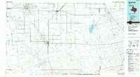
1985 Map of Seminole
USGS Topo · Published 1986About this map
Seminole serves as the central hub of this West Texas landscape, where the intersection of major roads anchors a region defined by its vast oil fields and intermittent drainage systems. The survey highlights the industrial footprint of the era, showing the Harris Field and numerous unnamed wells that drive the local economy. Transport is facilitated by the Atchison Topeka and Santa Fe railroad line, which cuts through the northern portion of Gaines County toward Seagraves. The terrain is characterized by a series of long, dry draws such as Mc Kenzie Draw and Seminole Draw, which lead toward significant natural landmarks like Cedar Lake (Salt). Smaller communities and crossroads like Fairview, Paynes Corner, and Higginbotham appear as vital points of reference for genealogists tracking family lands in these sprawling ranch and oil districts.
Find a feature on this map
37 named features on this map. Tap any name to fly to it.
Don’t see what you’re looking for? This feature index may not catch every label — zoom into the map to look around manually.
Map Details
Editions of this 1985 Seminole Map
This is the sole edition of this map. No revisions or reprints were ever made.
Other maps of this area

1954 · Lubbock
USGS Topo · 1:250,000

1954 · Hobbs
USGS Topo · 1:250,000

1954 · Big Spring
USGS Topo · 1:250,000

1954 · Brownfield
USGS Topo · 1:250,000

1958 · Brownfield
USGS Topo · 1:250,000

1958 · Big Spring
USGS Topo · 1:250,000

1958 · Hobbs
USGS Topo · 1:250,000

1962 · Brownfield
USGS Topo · 1:250,000

1966 · Wolcott Ranch
USGS Topo · 1:24,000

1966 · Flower Grove
USGS Topo · 1:24,000