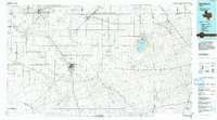
1992 Map of Seminole
USGS Topo · Published 1992About this map
Seminole serves as the regional hub for this West Texas landscape, where the intersection of state highways and long-established drainage patterns like Seminole Draw dictate the layout of the high plains. The map illustrates a region defined by its natural depressions and intermittent watercourses, most notably the large basin of Cedar (Salt) Lake and the branching paths of Sulphur Springs Draw and Mc Kenzie Draw. These draws are more than just topographical markers; they represent the historic hydrology that influenced early settlement and ranching routes through Gaines County.
Find a feature on this map
35 named features on this map. Tap any name to fly to it.
Don’t see what you’re looking for? This feature index may not catch every label — zoom into the map to look around manually.
Map Details
Editions of this 1992 Seminole Map
This is the sole edition of this map. No revisions or reprints were ever made.
Other maps of this area

1954 · Lubbock
USGS Topo · 1:250,000

1954 · Hobbs
USGS Topo · 1:250,000

1954 · Big Spring
USGS Topo · 1:250,000

1954 · Brownfield
USGS Topo · 1:250,000

1958 · Brownfield
USGS Topo · 1:250,000

1958 · Big Spring
USGS Topo · 1:250,000

1958 · Hobbs
USGS Topo · 1:250,000

1962 · Brownfield
USGS Topo · 1:250,000

1966 · Wolcott Ranch
USGS Topo · 1:24,000

1966 · Flower Grove
USGS Topo · 1:24,000