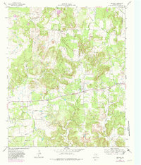
1964 Map of Senate
USGS Topo · Published 1982About this map
The small community of Senate serves as the focal point for this rural Jack County landscape, captured during a period of steady petroleum and agricultural activity. The terrain is defined by a dense network of intermittent watercourses, including North Creek, Henderson Creek, and the winding Salt Creek. Genealogists will find notable value in the recorded locations of Winn Hill Cem and Cottonwood Cem, alongside local spiritual centers like Bethany Ch and the Mountain Home Missionary Ch. Evidence of the region's industrial transitions is clear, with numerous Oil Well sites dotting the hills near Tater Hill and an Old Railroad Grade cutting across the central plains. This 1964 survey, with updates from the late 1970s, preserves the footprint of a North Texas ranching and oil-patch economy before further consolidation and modernization changed the local character.
Find a feature on this map
20 named features on this map. Tap any name to fly to it.
Don’t see what you’re looking for? This feature index may not catch every label — zoom into the map to look around manually.
Map Details
Editions of this 1964 Senate Map
2 editions found
Other maps of this area

1954 · Wichita Falls
USGS Topo · 1:250,000

1958 · Wichita Falls
USGS Topo · 1:250,000

1960 · Jacksboro
USGS Topo · 1:24,000
1961 · Bartons Chapel
USGS Topo · 1:24,000

1964 · Senate
USGS Topo · 1:24,000

1964 · Johnson Lake
USGS Topo · 1:24,000

1964 · Bryson
USGS Topo · 1:24,000

1964 · Lynn Creek
USGS Topo · 1:24,000
1964 · Markley
USGS Topo · 1:24,000
1967 · Long Hollow
USGS Topo · 1:24,000