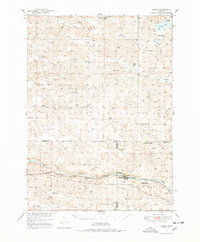
1948 Map of Seneca
USGS Topo · Published 1978About this map
Seneca stands as the primary hub along the Middle Loup River in this postwar survey of the Nebraska Sandhills. The landscape is defined by its ranching heritage, with large family holdings such as the Simonson and Lowe Ranch, Metz Ranch, and Prindle Ranch dotting the sprawling terrain. The presence of the Chicago Burlington and Quincy railroad following the river valley highlights the critical transport link for this cattle-producing region, connecting isolated outposts like Kelso to wider markets.
Find a feature on this map
35 named features on this map. Tap any name to fly to it.
Don’t see what you’re looking for? This feature index may not catch every label — zoom into the map to look around manually.
Map Details
Editions of this 1948 Seneca Map
3 editions found
Other maps of this area

1947 · Dismal River Ranch
USGS Topo · 1:62,500

1948 · Seneca
USGS Topo · 1:62,500

1948 · Thedford
USGS Topo · 1:62,500

1948 · Mullen
USGS Topo · 1:62,500

1948 · Seneca 4
USGS Topo · 1:62,500

1949 · Seneca 4
USGS Topo · 1:62,500

1949 · Dismal River Ranch
USGS Topo · 1:62,500

1949 · Big Falls
USGS Topo · 1:62,500

1950 · Thedford
USGS Topo · 1:62,500

1950 · Shimmins Lake
USGS Topo · 1:62,500