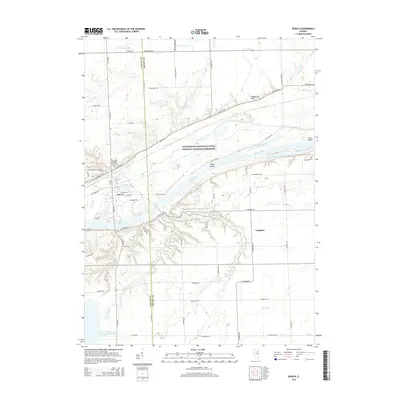
2015 Map of Seneca
USGS Topo · Published 2015About this map
The Illinois River corridor defines this portion of the midwestern landscape where the Illinois and Michigan Canal National Heritage Corridor runs parallel to the waterway. The village of Seneca serves as a central hub, split by the river and bordered by significant industrial and natural features. To the south, the massive LaSalle County Nuclear Station Cooling Pond indicates the modern energy infrastructure that occupies the rural landscape alongside traditional agricultural plots. Local history is preserved in sites like Mount Calvary Catholic Cem and Mount Hope Cem near the town center. The surrounding terrain is dissected by numerous named drainages such as Rat Run, Hog Run, and Deadly Run, while Holderman Hill provides a distinct overlook near the northern bluffs. This survey documents the intersection of 19th-century canal history with 21st-century power generation.
Find a feature on this map
62 named features on this map. Tap any name to fly to it.
Don’t see what you’re looking for? This feature index may not catch every label — zoom into the map to look around manually.
Map Details
Editions of this 2015 Seneca Map
This is the sole edition of this map. No revisions or reprints were ever made.
Other maps of this area

1892 · Morris
USGS Topo · 1:62,500

1892 · Marseilles
USGS Topo · 1:62,500

1916 · Marseilles
USGS Topo · 1:62,500

1918 · Morris
USGS Topo · 1:62,500

1940 · Marseilles
USGS Topo · 1:62,500

1948 · Dwight
USGS Topo · 1:62,500

1950 · Dwight
USGS Topo · 1:62,500

1953 · Morris
USGS Topo · 1:24,000

1953 · Lisbon
USGS Topo · 1:24,000
1954 · Morris
USGS Topo · 1:62,500