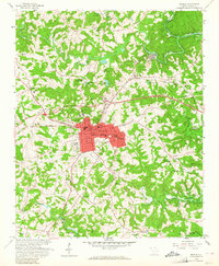
1958 Map of Seneca
USGS Topo · Published 1964About this map
Seneca and the industrial village of Utica stand at a point of significant transformation as the waters of the Hartwell Reservoir began to fill the surrounding valleys. The 1958 field check captures the area just as the landscape was being reshaped by the U.S. Army Corps of Engineers project, with dashed lines indicating areas subject to controlled inundation. This shift from a river-and-rail economy is evident as the Southern railroad lines continue to serve the central hub, while new shorelines emerge along the Little River.
Find a feature on this map
44 named features on this map. Tap any name to fly to it.
Don’t see what you’re looking for? This feature index may not catch every label — zoom into the map to look around manually.
Map Details
Editions of this 1958 Seneca Map
3 editions found

Other maps of this area

1886 · Walhalla
USGS Topo · 1:125,000

1888 · Pickens
USGS Topo · 1:125,000

1892 · Walhalla
USGS Topo · 1:125,000

1894 · Pickens
USGS Topo · 1:125,000

1896 · Walhalla
USGS Topo · 1:125,000

1950 · La France
USGS Topo · 1:24,000

1951 · La France
USGS Topo · 1:24,000

1951 · Clemson
USGS Topo · 1:24,000

1954 · Greenville
USGS Topo · 1:250,000

1958 · Greenville
USGS Topo · 1:250,000