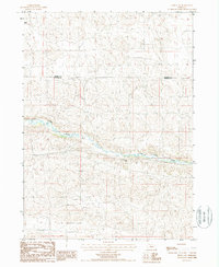
1988 Map of Seneca SW
USGS Topo · Published 1988About this map
The Middle Loup River winds through the heart of the Sandhills along the border of Cherry Co and Hooker Co, defining a landscape where water and ranching are the primary economic drivers. This late-twentieth-century survey documents a region characterized by sparse settlement and wide-open spaces, with local life centered around named homesteads such as Morris Ranch, Peterson Ranch, and Taylor Ranch. The small settlement of Keiso sits along the riverbank, serving as a focal point in an area otherwise dominated by the distinctive topography of Nebraska's dune country. A single Sand Pit near the river suggests small-scale local industry or material extraction, contrasting with the vast reaches of the surrounding ranch lands.
Find a feature on this map
7 named features on this map. Tap any name to fly to it.
Don’t see what you’re looking for? This feature index may not catch every label — zoom into the map to look around manually.
Map Details
Editions of this 1988 Seneca SW Map
This is the sole edition of this map. No revisions or reprints were ever made.
Other maps of this area

1947 · Dismal River Ranch
USGS Topo · 1:62,500

1948 · Seneca
USGS Topo · 1:62,500

1948 · Mullen
USGS Topo · 1:62,500

1949 · Dismal River Ranch
USGS Topo · 1:62,500

1950 · Shimmins Lake
USGS Topo · 1:62,500

1951 · Mullen
USGS Topo · 1:62,500

1951 · Seneca
USGS Topo · 1:62,500

1954 · North Platte
USGS Topo · 1:250,000

1956 · North Platte
USGS Topo · 1:250,000

1957 · North Platte
USGS Topo · 1:250,000