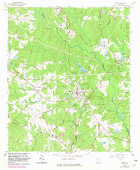
1965 Map of Senoia
USGS Topo · Published 1983About this map
Senoia and the southern edge of Peachtree City anchor this mid-1960s landscape, which was updated in the early 1980s to reflect suburban expansion along the Fayette Co Coweta Co line. The map illustrates a rural society in transition, where traditional land use patterns like the grain processing at Starrs Mill on Whitewater Creek exist alongside emerging infrastructure like Falcon Field and a growing network of paved roads. A series of small reservoirs and private lakes, including Marimac Lakes and Peoples Lakes, dot the drainage basins of Line Creek and Keg Creek. For the local historian, the map preserves the exact locations of several country congregations and burial grounds, such as Holly Grove Ch, Neriah Cem, and the Hartford Ch site. The Seaboard Coast Line railroad cuts a diagonal path through the terrain, serving as a primary corridor for the era's commerce between these developing Georgia communities.
Find a feature on this map
75 named features on this map. Tap any name to fly to it.
Don’t see what you’re looking for? This feature index may not catch every label — zoom into the map to look around manually.
Map Details
Editions of this 1965 Senoia Map
2 editions found
Other maps of this area

1953 · Atlanta
USGS Topo · 1:250,000

1957 · Atlanta
USGS Topo · 1:250,000

1958 · Atlanta
USGS Topo · 1:250,000

1965 · Tyrone
USGS Topo · 1:24,000

1965 · Fayetteville
USGS Topo · 1:24,000

1965 · Madras
USGS Topo · 1:24,000

1965 · Senoia
USGS Topo · 1:24,000

1965 · Brooks
USGS Topo · 1:24,000

1965 · Sharpsburg
USGS Topo · 1:24,000
1971 · Luthersville
USGS Topo · 1:24,000