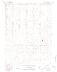
1961 Map of Sevenmile Gulch
USGS Topo · Published 1980About this map
Emigrant Trail and the Overland Trail converge in this high desert landscape, marking a corridor of westward migration through Sweetwater County. The terrain is defined by the drainage patterns of Sevenmile Gulch and Sevenmile Wash, which cut through the arid plains toward Blacks Fork. These routes represent the physical intersection of 19th-century pioneer paths with the industrial infrastructure of the mid-20th century, evidenced by the modern Pipeline that traverses the same territory.
Find a feature on this map
10 named features on this map. Tap any name to fly to it.
Don’t see what you’re looking for? This feature index may not catch every label — zoom into the map to look around manually.
Map Details
Editions of this 1961 Sevenmile Gulch Map
2 editions found
Other maps of this area

1954 · Ogden
USGS Topo · 1:250,000

1954 · Rock Springs
USGS Topo · 1:250,000

1958 · Ogden
USGS Topo · 1:250,000

1958 · Rock Springs
USGS Topo · 1:250,000

1960 · Ogden
USGS Topo · 1:250,000

1961 · Blue Point
USGS Topo · 1:24,000

1961 · Little America
USGS Topo · 1:24,000

1961 · Sevenmile Gulch
USGS Topo · 1:24,000

1961 · Granger
USGS Topo · 1:24,000

1962 · Rock Springs
USGS Topo · 1:250,000