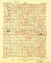
1941 Map of Severy
USGS Topo · Published 1941About this map
Severy serves as the central rail hub on this 1930s landscape, positioned at the junction where the Atchison Topeka and Santa Fe RR meets the St Louis San Francisco RR. This intersection supported a network of rural school districts and small communities across the Greenwood and Elk county line. The terrain is defined by the winding course of the Fall River and its numerous tributaries, including Salt Creek and Indian Creek, which dictated the placement of early settlements and roads.
Find a feature on this map
66 named features on this map. Tap any name to fly to it.
Don’t see what you’re looking for? This feature index may not catch every label — zoom into the map to look around manually.
Map Details
Editions of this 1941 Severy Map
3 editions found

Other maps of this area

1885 · Eureka
USGS Topo · 1:125,000

1885 · Sedan
USGS Topo · 1:125,000

1886 · Fredonia
USGS Topo · 1:125,000

1886 · Independence
USGS Topo · 1:125,000

1888 · Eureka
USGS Topo · 1:125,000

1889 · Sedan
USGS Topo · 1:125,000

1894 · Fredonia
USGS Topo · 1:125,000

1894 · Independence
USGS Topo · 1:125,000

1894 · Eureka
USGS Topo · 1:125,000

1905 · Independence
USGS Topo · 1:125,000