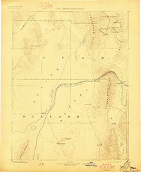
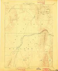
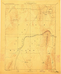
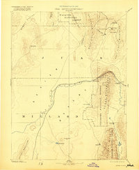
1885 Map of Sevier Desert
USGS Topo · Published 1897About this map
Mining camps and early territorial settlements anchor this late-nineteenth-century survey of the eastern Great Basin. In the northern reaches, the concentrated silver and lead district of the Tintic Mountains comes into focus, featuring active mining centers like Silver City and Diamond City. These industrial hubs are connected to the broader region by the Utah Central Railroad, which follows the curve of the Sevier River as it winds through the Sevier Cañon. To the south and west, the vast expanse of the Sevier Desert is punctuated by isolated watering points like Marmaduke Spring and the agricultural outpost of Deseret. Along the eastern margin, established towns such as Scipio and Holden sit at the foot of the Canon Mountains, illustrating the early irrigation-based settlement patterns typical of central Utah before the turn of the century.
Find a feature on this map
31 named features on this map. Tap any name to fly to it.
Don’t see what you’re looking for? This feature index may not catch every label — zoom into the map to look around manually.
Map Details
Editions of this 1885 Sevier Desert Map
5 editions found
Other maps of this area

1885 · Salt Lake
USGS Topo · 1:250,000

1885 · Manti
USGS Topo · 1:250,000

1885 · Beaver
USGS Topo · 1:250,000

1885 · Sevier Desert
USGS Topo · 1:250,000

1885 · Fish Lake
USGS Topo · 1:250,000

1885 · Tooele Valley
USGS Topo · 1:250,000

1895 · Manti
USGS Topo · 1:250,000

1896 · Fish Lake
USGS Topo · 1:250,000

1908 · Fish Springs
USGS Topo · 1:250,000

1910 · Fish Springs
USGS Topo · 1:250,000