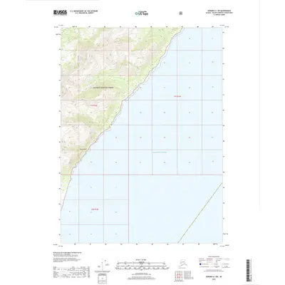
2018 Map of Seward A-1 SW
USGS Topo · Published 2018About this map
Chugach National Forest lands meet the sea along this coastal segment of the Kenai Peninsula in the late 2010s. The map captures a dramatic transition from the high, glacier-carved topography of the Alaskan interior to the open waters of the Gulf of Alaska. The interior terrain is defined by steep elevation gains, rising quickly from the shoreline into complex ridges and peaks. A notable coastal landmark, Purple Bluff, stands out as a prominent feature along the steep shoreline, where the mountains descend directly into the sea. This survey is primarily a study of wilderness and topography, showing no roads or permanent settlements, but illustrating the precise township and range boundaries including t1s r12e, t1s r13e, and t2s r12e that overlay these protected federal lands.
Find a feature on this map
6 named features on this map. Tap any name to fly to it.
Don’t see what you’re looking for? This feature index may not catch every label — zoom into the map to look around manually.
Map Details
Editions of this 2018 Seward A-1 SW Map
This is the sole edition of this map. No revisions or reprints were ever made.
Other maps of this area

1946 · Blying Sound
USGS Topo · 1:250,000

1951 · Blying Sound
USGS Topo · 1:250,000

1951 · Seward
USGS Topo · 1:250,000

1951 · Seward A-2
USGS Topo · 1:63,360

1951 · Blying Sound D-1 and D-2
USGS Topo · 1:63,360

1951 · Seward A-1
USGS Topo · 1:63,360

1953 · Seward A-2
USGS Topo · 1:63,360

1953 · Seward A-1
USGS Topo · 1:63,360
1953 · Blying Sound D-1 and D-2
USGS Topo · 1:63,360

1953 · Blying Sound
USGS Topo · 1:250,000