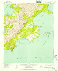
1953 Map of Blying Sound D-1 and D-2
USGS Topo · Published 1954About this map
Montague Island dominates this mid-century coastal survey, situated where the Montague Strait meets the Gulf of Alaska. The landscape is defined by its deep maritime inlets and short river systems, most notably the Nellie Martin River which drains into the expansive Patton Bay. Human presence is minimal, evidenced only by a single Cabin at the northern tip near Pt Bazil.
Find a feature on this map
19 named features on this map. Tap any name to fly to it.
Don’t see what you’re looking for? This feature index may not catch every label — zoom into the map to look around manually.
Map Details
Editions of this 1953 Blying Sound D-1 and D-2 Map
2 editions found
Other maps of this area

1946 · Blying Sound
USGS Topo · 1:250,000

1951 · Blying Sound
USGS Topo · 1:250,000

1951 · Seward
USGS Topo · 1:250,000

1951 · Seward A-2
USGS Topo · 1:63,360

1951 · Seward A-3
USGS Topo · 1:63,360

1951 · Blying Sound D-1 and D-2
USGS Topo · 1:63,360

1951 · Seward A-1
USGS Topo · 1:63,360

1952 · Seward A-3
USGS Topo · 1:63,360

1953 · Seward A-2
USGS Topo · 1:63,360

1953 · Seward A-1
USGS Topo · 1:63,360