
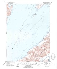
1953 Map of Seward A-2
USGS Topo · Published 1954About this map
Montague Strait serves as the dominant marine corridor in this mid-century survey, separating the high elevations of Montague Island from the northern reaches of Knight Island. The maritime character of the region is defined by deep-water soundings and navigational hazards like The Needle, a lonely rock rising from the center of the strait. On Knight Island, the landscape is punctuated by Horn Mountain and the sheltered waters of Snug Harbor, while the southern portion of the map is dominated by the mountainous terrain of the Chugach National Forest on Montague Island. The inclusion of Beach River and Discovery Pt provides specific reference points for maritime history and geological study. This 1953 topography reflects the untouched coastline of the Prince William Sound area before major modern environmental changes, capturing the complex island-and-channel network exactly as it appeared to the Geological Survey in the early 1950s.
Find a feature on this map
13 named features on this map. Tap any name to fly to it.
Don’t see what you’re looking for? This feature index may not catch every label — zoom into the map to look around manually.
Map Details
Editions of this 1953 Seward A-2 Map
2 editions found
Other maps of this area

1946 · Blying Sound
USGS Topo · 1:250,000

1950 · Seward B-3
USGS Topo · 1:63,360

1951 · Blying Sound
USGS Topo · 1:250,000

1951 · Seward
USGS Topo · 1:250,000

1951 · Seward B-1
USGS Topo · 1:63,360

1951 · Seward A-2
USGS Topo · 1:63,360

1951 · Seward A-3
USGS Topo · 1:63,360

1951 · Blying Sound D-1 and D-2
USGS Topo · 1:63,360

1951 · Seward A-1
USGS Topo · 1:63,360

1951 · Seward B-2
USGS Topo · 1:63,360