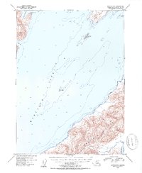
1953 Map of Seward A-2
USGS Topo · Published 1954About this map
Montague Strait dominates the maritime geography of this 1953 maritime survey, serving as the deep-water passage between Knight Island and Montague Island. The hydrography, compiled from earlier charts and aerial photography, reveals the coastal hazards of the Prince William Sound region, including the isolated rock formation known as The Needle. On the northern coast of Montague Island, the mouth of Beach River meets the Gulf of Alaska, while to the northwest, the sheltered waters of Snug Harbor and Hogan Bay provide refuge below the heights of Horn Mountain. The entire land area is situated within the Chugach National Forest, reflecting the undeveloped wilderness character of the Alaska-Third Judicial Division in the early fifties. Small outcroppings like Green Island and Little Green Island dot the strait, illustrating the complex navigation required through these northern channels.
Find a feature on this map
14 named features on this map. Tap any name to fly to it.
Don’t see what you’re looking for? This feature index may not catch every label — zoom into the map to look around manually.
Map Details
Editions of this 1953 Seward A-2 Map
2 editions found

Other maps of this area

1946 · Blying Sound
USGS Topo · 1:250,000

1950 · Seward B-3
USGS Topo · 1:63,360

1951 · Blying Sound
USGS Topo · 1:250,000

1951 · Seward
USGS Topo · 1:250,000

1951 · Seward B-1
USGS Topo · 1:63,360

1951 · Seward A-2
USGS Topo · 1:63,360

1951 · Seward A-3
USGS Topo · 1:63,360

1951 · Blying Sound D-1 and D-2
USGS Topo · 1:63,360

1951 · Seward A-1
USGS Topo · 1:63,360

1951 · Seward B-2
USGS Topo · 1:63,360