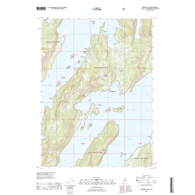
2018 Map of Seward A-3 SW
USGS Topo · Published 2018About this map
Port Ashton and the modern community at Chenega Bay serve as focal points for maritime and aviation activity in this remote coastal corner of the Chugach National Forest. The landscape is dominated by the complex coastlines of Evans Island and Elrington Island, separated by the deep waters of Prince of Wales Passage and Elrington Passage. Navigation is key here, with local landmarks ranging from the Iktua Rocks in the north to the Chenega Bay Airport perched above Crab Bay.
Find a feature on this map
26 named features on this map. Tap any name to fly to it.
Don’t see what you’re looking for? This feature index may not catch every label — zoom into the map to look around manually.
Map Details
Editions of this 2018 Seward A-3 SW Map
This is the sole edition of this map. No revisions or reprints were ever made.
Other maps of this area

1946 · Blying Sound
USGS Topo · 1:250,000

1950 · Blying Sound D-4
USGS Topo · 1:63,360

1951 · Blying Sound
USGS Topo · 1:250,000

1951 · Seward
USGS Topo · 1:250,000

1951 · Seward A-3
USGS Topo · 1:63,360

1951 · Seward A-4
USGS Topo · 1:63,360

1952 · Seward A-3
USGS Topo · 1:63,360

1952 · Seward A-4
USGS Topo · 1:63,360
1952 · Blying Sound D-4
USGS Topo · 1:63,360
1953 · Blying Sound D-3
USGS Topo · 1:63,360