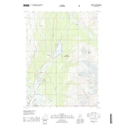
2018 Map of Seward A-7 NE
USGS Topo · Published 2018About this map
Bear Creek and Woodrow serve as the primary residential hubs north of Seward in this 2018 topographic survey. The landscape is defined by the steep slopes of the Kenai Mountains, where peaks like Tiehacker Mtn and Mt Alice overlook the glacial valley floor. Transportation patterns are clearly visible, with the Seward Highway running parallel to the Resurrection River and providing access to the regional Seward Airport. Local history and genealogy interest is found at the Woodlawn Cem and American Legion Cem located near the northern edge of the city limits. The map also documents extensive recreational infrastructure within the Chugach National Forest, including the Lost Lake Trail and the historic INHT: Bear Lake Trail. Water features like Bear Lake and the South Fork Snow River dominate the lowlands, reflecting the area's complex drainage system.
Find a feature on this map
53 named features on this map. Tap any name to fly to it.
Don’t see what you’re looking for? This feature index may not catch every label — zoom into the map to look around manually.
Map Details
Editions of this 2018 Seward A-7 NE Map
This is the sole edition of this map. No revisions or reprints were ever made.
Other maps of this area

1950 · Seward A-6
USGS Topo · 1:63,360

1950 · Seward A-7
USGS Topo · 1:63,360

1951 · Seward
USGS Topo · 1:250,000

1951 · Seward A-6
USGS Topo · 1:63,360

1951 · Seward A-7
USGS Topo · 1:63,360

1951 · Seward B-7
USGS Topo · 1:63,360

1951 · Seward B-6
USGS Topo · 1:63,360

1952 · Seward B-6
USGS Topo · 1:63,360

1953 · Seward B-7
USGS Topo · 1:63,360

1953 · Seward
USGS Topo · 1:250,000