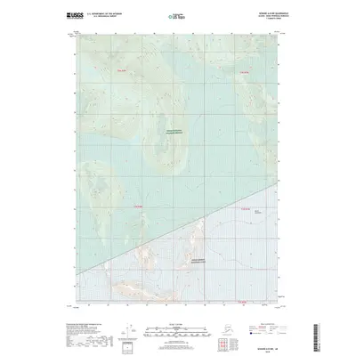
2018 Map of Seward A-8 NW
USGS Topo · Published 2018About this map
Kenai Peninsula terrain dominates this 2018 survey, which illustrates the boundary between two significant federal conservation areas. The high-elevation glaciated landscape is divided between the Kenai National Wildlife Refuge to the north and the Kenai Fjords National Park to the south. This transition reveals the dramatic topography of the region, where steep slopes and alpine features define the wilderness. In the northern section, the headwaters of the Russian River are visible, cutting through the high country. The map serves as a technical record of the land division within the Public Land Survey System, specifically detailing portions of t1n r4w and t1n r3w, showcasing how these remote administrative boundaries overlay the natural geography of the peninsula.
Find a feature on this map
9 named features on this map. Tap any name to fly to it.
Don’t see what you’re looking for? This feature index may not catch every label — zoom into the map to look around manually.
Map Details
Editions of this 2018 Seward A-8 NW Map
This is the sole edition of this map. No revisions or reprints were ever made.
Other maps of this area

1944 · Kenai
USGS Topo · 1:250,000

1950 · Kenai
USGS Topo · 1:250,000

1950 · Kenai B-1
USGS Topo · 1:63,360

1950 · Seward A-8
USGS Topo · 1:63,360

1951 · Seward
USGS Topo · 1:250,000

1951 · Kenai A-1
USGS Topo · 1:63,360

1951 · Seward B-8
USGS Topo · 1:63,360

1951 · Seward A-8
USGS Topo · 1:63,360
1952 · Seward A-8
USGS Topo · 1:63,360

1952 · Kenai A-1
USGS Topo · 1:63,360