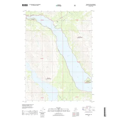
2018 Map of Seward B-8 NE
USGS Topo · Published 2018About this map
Snug Harbor sits at the northwestern edge of Kenai Lake, serving as a focal point for this section of the Chugach National Forest in 2018. The landscape is defined by the massive glacial waters of Kenai Lake, which stretches south through the center of the sheet, and the high-elevation Cooper Lake to the southwest. Transport and accessibility are concentrated in the north along the Sterling Highway, where the Quartz Creek Airport and Quartz Creek Rd provide entry to the backcountry. The map captures the meeting of managed infrastructure and wilderness, with the steep slopes of Right Mtn and the isolated Porcupine Island framing the water. Numerous drainages like Crescent Cr and Shackleford Cr feed into the lake system, illustrating the complex hydrology of the Kenai Peninsula.
Find a feature on this map
21 named features on this map. Tap any name to fly to it.
Don’t see what you’re looking for? This feature index may not catch every label — zoom into the map to look around manually.
Map Details
Editions of this 2018 Seward B-8 NE Map
This is the sole edition of this map. No revisions or reprints were ever made.
Other maps of this area

1951 · Seward
USGS Topo · 1:250,000

1951 · Seward B-7
USGS Topo · 1:63,360

1951 · Seward C-8
USGS Topo · 1:63,360

1951 · Seward B-8
USGS Topo · 1:63,360

1951 · Seward C-7
USGS Topo · 1:63,360

1952 · Seward C-8
USGS Topo · 1:63,360
1952 · Seward B-8
USGS Topo · 1:63,360

1953 · Seward C-7
USGS Topo · 1:63,360

1953 · Seward B-7
USGS Topo · 1:63,360

1953 · Seward
USGS Topo · 1:250,000