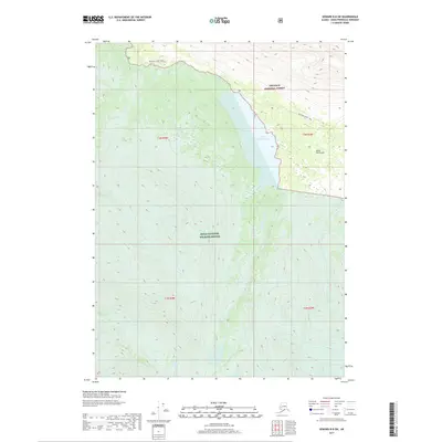
2017 Map of Seward B-8 SW
USGS Topo · Published 2017About this map
Upper Russian Lake sits at the heart of this high-latitude terrain, serving as a central drainage point for the surrounding mountains of the Kenai Peninsula. The Russian River flows northward from the lake, paralleled in sections by the Russian Lakes Trail, a key corridor for backcountry access. This 2017 survey captures a preserved wilderness landscape divided between the Chugach National Forest to the northeast and the Kenai National Wildlife Refuge to the southwest. The topographic detail highlights the steep drainage patterns of Summit Creek and Summit Cr along the eastern edge of the quadrangle, illustrating the complex hydrology of this subarctic environment where trails and waterways are the primary landmarks.
Find a feature on this map
12 named features on this map. Tap any name to fly to it.
Don’t see what you’re looking for? This feature index may not catch every label — zoom into the map to look around manually.
Map Details
Editions of this 2017 Seward B-8 SW Map
This is the sole edition of this map. No revisions or reprints were ever made.
Other maps of this area

1944 · Kenai
USGS Topo · 1:250,000

1950 · Kenai
USGS Topo · 1:250,000

1950 · Kenai B-1
USGS Topo · 1:63,360

1950 · Seward A-8
USGS Topo · 1:63,360

1951 · Seward
USGS Topo · 1:250,000

1951 · Kenai A-1
USGS Topo · 1:63,360

1951 · Seward B-8
USGS Topo · 1:63,360

1951 · Seward A-8
USGS Topo · 1:63,360
1952 · Seward A-8
USGS Topo · 1:63,360

1952 · Kenai A-1
USGS Topo · 1:63,360