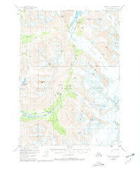
1951 Map of Seward C-6
USGS Topo · Published 1981About this map
The Alaska Railroad serves as the industrial spine of this mid-century landscape, threading through the high passes and tunnels of the Chugach National Forest. The route follows the Placer River valley, connecting small trackside points such as Spencer and Grandview before crossing south toward Hunter. This transportation corridor is defined by its proximity to massive ice fields, including the crevassed reaches of Spencer Glacier and Bartlett Glacier.
Find a feature on this map
35 named features on this map. Tap any name to fly to it.
Don’t see what you’re looking for? This feature index may not catch every label — zoom into the map to look around manually.
Map Details
Editions of this 1951 Seward C-6 Map
4 editions found
Other maps of this area

1951 · Seward
USGS Topo · 1:250,000

1951 · Seward B-7
USGS Topo · 1:63,360

1951 · Seward C-6
USGS Topo · 1:63,360

1951 · Seward D-5
USGS Topo · 1:63,360

1951 · Seward C-5
USGS Topo · 1:63,360

1951 · Seward B-6
USGS Topo · 1:63,360

1951 · Seward B-5
USGS Topo · 1:63,360

1951 · Seward D-7
USGS Topo · 1:63,360

1951 · Seward C-7
USGS Topo · 1:63,360

1951 · Seward D-6
USGS Topo · 1:63,360