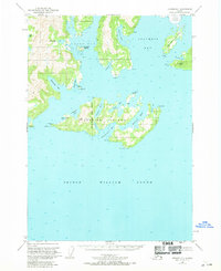
1951 Map of Seward D-1
USGS Topo · Published 1969About this map
Glacier Island dominates this 1950s maritime study of the northern reaches of Prince William Sound. Located within the Chugach National Forest, the island's coastline is intricately carved by Jackson Hole, Eagle Bay, and Chamberlain Bay, with isolated Cabin structures appearing on its eastern shore. These small buildings, along with others at Irish Cove and Finski Bay, suggest a landscape defined by seasonal fishing and trapping rather than permanent township development.
Find a feature on this map
37 named features on this map. Tap any name to fly to it.
Don’t see what you’re looking for? This feature index may not catch every label — zoom into the map to look around manually.
Map Details
Editions of this 1951 Seward D-1 Map
3 editions found
Other maps of this area

1948 · Cordova
USGS Topo · 1:250,000

1950 · Cordova C-8
USGS Topo · 1:63,360

1951 · Seward
USGS Topo · 1:250,000

1951 · Anchorage
USGS Topo · 1:250,000

1951 · Cordova
USGS Topo · 1:250,000

1951 · Seward D-2
USGS Topo · 1:63,360

1951 · Seward D-1
USGS Topo · 1:63,360

1951 · Cordova D-8
USGS Topo · 1:63,360

1951 · Seward C-1
USGS Topo · 1:63,360

1951 · Seward C-2
USGS Topo · 1:63,360