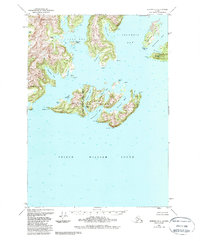
1951 Map of Seward D-1
USGS Topo · Published 1988About this map
Glacier Island dominates the central waters of this maritime survey, acting as a natural breakwater between the open expanse of Prince William Sound and the intricate coastline to the north. The map documents a complex glacial landscape where Columbia Bay and Heather Bay meet the sea, defined by deep-water passages and numerous small harbors such as Irish Cove and Finski Bay. A notable cartographic detail is the convergence of the Seward Meridian and Copper River Meridian, which slice through the western edge of Glacier Island.
Find a feature on this map
31 named features on this map. Tap any name to fly to it.
Don’t see what you’re looking for? This feature index may not catch every label — zoom into the map to look around manually.
Map Details
Editions of this 1951 Seward D-1 Map
3 editions found
Other maps of this area

1948 · Cordova
USGS Topo · 1:250,000

1950 · Cordova C-8
USGS Topo · 1:63,360

1951 · Seward
USGS Topo · 1:250,000

1951 · Anchorage
USGS Topo · 1:250,000

1951 · Cordova
USGS Topo · 1:250,000

1951 · Seward D-2
USGS Topo · 1:63,360

1951 · Seward D-1
USGS Topo · 1:63,360

1951 · Cordova D-8
USGS Topo · 1:63,360

1951 · Seward C-1
USGS Topo · 1:63,360

1951 · Seward C-2
USGS Topo · 1:63,360