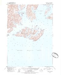
1952 Map of Seward D-1
USGS Topo · Published 1954About this map
Glacier Island dominates this maritime landscape within Prince William Sound, its complex coastline defined by deep indentations like Chamberlain Bay and Growler Bay. In the early 1950s, this area of the Chugach National Forest remained largely undeveloped, characterized by isolated Cabins and navigational landmarks for those traversing the Alaskan coast. To the north, the massive Columbia Glacier discharges into the head of Columbia Bay, while Long Bay provides sheltered waters behind Schrader Island. The map records a series of named points and coves crucial for maritime navigation, such as Slipper Pt and Useless Cove, reflecting the practical nomenclature of mariners and hunters who navigated these waters before more modern infrastructure arrived.
Find a feature on this map
34 named features on this map. Tap any name to fly to it.
Don’t see what you’re looking for? This feature index may not catch every label — zoom into the map to look around manually.
Map Details
Editions of this 1952 Seward D-1 Map
2 editions found

Other maps of this area

1948 · Cordova
USGS Topo · 1:250,000

1950 · Cordova C-8
USGS Topo · 1:63,360

1951 · Seward
USGS Topo · 1:250,000

1951 · Anchorage
USGS Topo · 1:250,000

1951 · Cordova
USGS Topo · 1:250,000

1951 · Seward D-2
USGS Topo · 1:63,360

1951 · Seward D-1
USGS Topo · 1:63,360

1951 · Cordova D-8
USGS Topo · 1:63,360

1951 · Seward C-1
USGS Topo · 1:63,360

1951 · Seward C-2
USGS Topo · 1:63,360