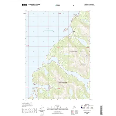
2018 Map of Seward D-3 NW
USGS Topo · Published 2018About this map
Chugach National Forest dominates this coastal landscape where the waters of Prince William Sound meet the jagged shoreline of south-central Alaska. The map centers on the northern reach of Esther Island, defined by the narrow waterway of Esther Passage to the east and the expansive Port Wells to the west. The small settlement of Golden is positioned on the northeastern coast, providing a rare point of human habitation in this wilderness area. The island's interior is accessible via the North Portage Tr, which connects the coastal inlets across the high, glaciated terrain. Significant water features like Avery River and Davis Lake drain the mainland slopes, while Granite Bay carves into the southwestern coast of the island. This topographic survey captures the complex intersection of fjord-like passages and protected forest lands before the latest shift in maritime and environmental data.
Find a feature on this map
19 named features on this map. Tap any name to fly to it.
Don’t see what you’re looking for? This feature index may not catch every label — zoom into the map to look around manually.
Map Details
Editions of this 2018 Seward D-3 NW Map
This is the sole edition of this map. No revisions or reprints were ever made.
Other maps of this area

1951 · Seward
USGS Topo · 1:250,000

1951 · Anchorage
USGS Topo · 1:250,000

1951 · Seward D-4
USGS Topo · 1:63,360

1951 · Seward D-3
USGS Topo · 1:63,360

1952 · Seward D-3
USGS Topo · 1:63,360

1952 · Seward D-4
USGS Topo · 1:63,360

1953 · Seward
USGS Topo · 1:250,000

1959 · Seward
USGS Topo · 1:250,000

1960 · Anchorage A-4
USGS Topo · 1:63,360

1960 · Anchorage A-3
USGS Topo · 1:63,360