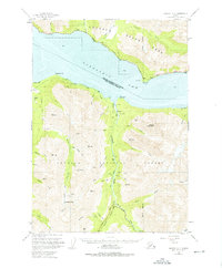
1951 Map of Seward D-7
USGS Topo · Published 1975About this map
Turnagain Arm separates the mountainous terrain of the Kenai Peninsula from the mainland, where the Alaska Railroad and Seward Highway trace the northern shoreline through Bird. To the south, the landscape is defined by the legacy of early 20th-century mining within the Chugach National Forest. Evidence of prospecting is concentrated along Sixmile Creek and Palmer Creek, where the map identifies the Connolly Mine, Nearhouse Mine, and Downing Mine.
Find a feature on this map
51 named features on this map. Tap any name to fly to it.
Don’t see what you’re looking for? This feature index may not catch every label — zoom into the map to look around manually.
Map Details
Editions of this 1951 Seward D-7 Map
3 editions found
Other maps of this area

1951 · Seward
USGS Topo · 1:250,000

1951 · Anchorage
USGS Topo · 1:250,000

1951 · Seward C-6
USGS Topo · 1:63,360

1951 · Seward C-8
USGS Topo · 1:63,360

1951 · Seward D-8
USGS Topo · 1:63,360

1951 · Seward D-7
USGS Topo · 1:63,360

1951 · Seward C-7
USGS Topo · 1:63,360

1951 · Seward D-6
USGS Topo · 1:63,360

1952 · Seward C-6
USGS Topo · 1:63,360

1952 · Seward D-8
USGS Topo · 1:63,360