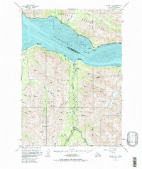
1951 Map of Seward D-7
USGS Topo · Published 1975About this map
The waters of Turnagain Arm separate the coastal settlements of the Kenai Peninsula from the northern rail corridor in this early 1950s survey. Along the southern shore, the community of Sunrise serves as a focal point for a region deeply tied to mineral extraction, evidenced by numerous named claims such as the Connolly Mine and Sunshine Mine. These mining sites follow the drainage of Sixmile Creek and its tributaries, where remote outposts like Swetmann Camp and Silvertip provided base operations for prospectors working the interior gulches.
Find a feature on this map
60 named features on this map. Tap any name to fly to it.
Don’t see what you’re looking for? This feature index may not catch every label — zoom into the map to look around manually.
Map Details
Editions of this 1951 Seward D-7 Map
3 editions found
Other maps of this area

1951 · Seward
USGS Topo · 1:250,000

1951 · Anchorage
USGS Topo · 1:250,000

1951 · Seward C-6
USGS Topo · 1:63,360

1951 · Seward C-8
USGS Topo · 1:63,360

1951 · Seward D-8
USGS Topo · 1:63,360

1951 · Seward D-7
USGS Topo · 1:63,360

1951 · Seward C-7
USGS Topo · 1:63,360

1951 · Seward D-6
USGS Topo · 1:63,360

1952 · Seward C-6
USGS Topo · 1:63,360

1952 · Seward D-8
USGS Topo · 1:63,360