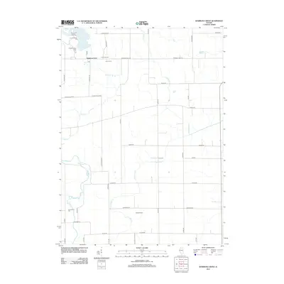
2012 Map of Shabbona Grove
USGS Topo · Published 2012About this map
Shabbona Grove and the agricultural lands of southern DeKalb County are defined by a grid of rural roads and the winding paths of Indian Cr and Little Indian Cr. This 2012 survey captures the area during a period of transition, where legacy agricultural sites like Timber Edge Farm and Johnson Farm sit alongside modern recreation at Shabbona Lake. Local history is preserved in small, dedicated plots such as Old Stevens Cem and Victor Cem, which anchor the landscape to earlier generations of settlers. The presence of Dewey Airport and several specialized park grounds, including the Three Fires Picnic Area and Sommonauk Point Picnic Area, illustrates the integration of public space and private aviation into this traditional farming community.
Find a feature on this map
41 named features on this map. Tap any name to fly to it.
Don’t see what you’re looking for? This feature index may not catch every label — zoom into the map to look around manually.
Map Details
Editions of this 2012 Shabbona Grove Map
This is the sole edition of this map. No revisions or reprints were ever made.
Other maps of this area

1934 · De Kalb
USGS Topo · 1:62,500

1937 · De Kalb
USGS Topo · 1:62,500

1937 · Sycamore
USGS Topo · 1:62,500

1948 · Sandwich
USGS Topo · 1:62,500

1950 · Sandwich
USGS Topo · 1:62,500

1951 · Earlville
USGS Topo · 1:62,500

1958 · Aurora
USGS Topo · 1:250,000

1961 · Aurora
USGS Topo · 1:250,000
1968 · Hinckley
USGS Topo · 1:24,000
1971 · Leland
USGS Topo · 1:24,000