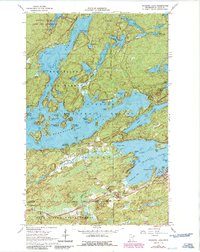
1965 Map of Shagawa Lake
USGS Topo · Published 1986About this map
The edge of Ely serves as the gateway to this lake-dominated wilderness at the northern reaches of the Superior National Forest. A complex network of glaciated waterways defines the landscape, including the sprawling Shagawa Lake and the northern arm of Burntside. The map documents the protected character of the region within the Boundary Waters Canoe Area Wilderness and the Burntside State Forest. Human infrastructure is concentrated in the southeast, where the Duluth Missabe and Iron Range railroad and an Aqueduct follow the corridor near Armstrong Creek. For those interested in recreation history, the map details established points such as Semer Park and the Fenske Lake Campground, alongside numerous named islands including Honeymoon Island and Blueberry Island. This 1960s survey, updated in the mid-1980s, preserves the mid-century layout of the lakeshore before later development changed the fringes of the wilderness.
Find a feature on this map
69 named features on this map. Tap any name to fly to it.
Don’t see what you’re looking for? This feature index may not catch every label — zoom into the map to look around manually.
Map Details
Editions of this 1965 Shagawa Lake Map
3 editions found
Other maps of this area

1933 · Ely
USGS Topo · 1:62,500

1939 · Ely
USGS Topo · 1:62,500

1954 · Two Harbors
USGS Topo · 1:250,000

1954 · Hibbing
USGS Topo · 1:250,000

1954 · International Falls
USGS Topo · 1:250,000

1956 · Crab Lake
USGS Topo · 1:24,000

1956 · Eagles Nest
USGS Topo · 1:24,000

1957 · Two Harbors
USGS Topo · 1:250,000

1957 · Hibbing
USGS Topo · 1:250,000

1957 · International Falls
USGS Topo · 1:250,000