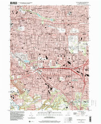
1994 Map of Shaker Heights
USGS Topo · Published 2000About this map
Shaker Heights and its neighboring eastern suburbs define this landscape, where early 1990s residential development is deeply integrated with planned green spaces and institutional grounds. The area is anchored by John Carroll University in University Heights and the expansive Highland Park Cemetery. The drainage patterns of Shaker Brook feeding into Lower Shaker Lake and Upper Shaker Lake illustrate the suburban planning that preserved water features as central community assets.
Find a feature on this map
126 named features on this map. Tap any name to fly to it.
Don’t see what you’re looking for? This feature index may not catch every label — zoom into the map to look around manually.
Map Details
Editions of this 1994 Shaker Heights Map
This is the sole edition of this map. No revisions or reprints were ever made.
Other maps of this area

1901 · Euclid
USGS Topo · 1:62,500

1903 · Cleveland
USGS Topo · 1:62,500

1903 · Euclid
USGS Topo · 1:62,500

1905 · Mentor
USGS Topo · 1:62,500

1906 · Chagrin Falls
USGS Topo · 1:62,500

1907 · Mentor
USGS Topo · 1:62,500

1908 · Chagrin Falls
USGS Topo · 1:62,500

1950 · Cleveland
USGS Topo · 1:250,000

1953 · Chagrin Falls
USGS Topo · 1:24,000

1953 · Shaker Heights
USGS Topo · 1:24,000