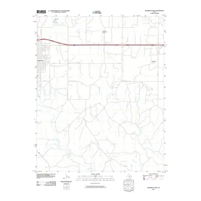
2010 Map of Shamrock East
USGS Topo · Published 2010About this map
Shamrock anchors this section of Wheeler County, where the eastern edge of the city gives way to the agricultural landscape of the Texas Panhandle. The topography is defined by a dendritic network of drainage systems, including Hackberry Creek, Elm Creek, and Raven Creek, which move through the ranching and farming country south of the Interstate. North of the town, infrastructure includes the Shamrock Municipal Airport and Blakemore Dam, which contains the waters of Stagg Lake. The map reveals a transition from the urban grid of Shamrock, with streets like E 12th St, to a rural network of county roads and farm-to-market routes such as FM 2033. The small settlement of Norrick appears in the eastern portion of the quadrangle, situated along the Farm to Market road system that services the surrounding plains.
Find a feature on this map
25 named features on this map. Tap any name to fly to it.
Don’t see what you’re looking for? This feature index may not catch every label — zoom into the map to look around manually.
Map Details
Editions of this 2010 Shamrock East Map
This is the sole edition of this map. No revisions or reprints were ever made.
Other maps of this area

1954 · Amarillo
USGS Topo · 1:250,000

1958 · Amarillo
USGS Topo · 1:250,000

1962 · Twitty
USGS Topo · 1:24,000

1962 · Kelton SE
USGS Topo · 1:24,000

1962 · Wheeler SE
USGS Topo · 1:24,000

1963 · Fulller
USGS Topo · 1:24,000

1963 · Shamrock East
USGS Topo · 1:24,000

1963 · Shamrock West
USGS Topo · 1:24,000

1963 · Little Wolf Creek
USGS Topo · 1:24,000
1964 · Dozier
USGS Topo · 1:24,000