
1963 Map of Shamrock East
USGS Topo · Published 1967About this map
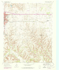
Shamrock anchors the northwestern corner of this Texas Panhandle survey, showing a developed street grid during a period of mid-century growth. The town's social and educational infrastructure is clearly visible through facilities like North Ward Sch, Jr High Sch, and the High Sch, along with local recreation sites such as Elmore Park and a Drive-in Theater along the main road. The economy of the era is defined by the heavy presence of an Oil and Gas Field and a network of pipelines cutting across the landscape.
Find a feature on this map
22 named features on this map. Tap any name to fly to it.
Don’t see what you’re looking for? This feature index may not catch every label — zoom into the map to look around manually.
Map Details
Editions of this 1963 Shamrock East Map
2 editions found
Other maps of this area

1954 · Amarillo
USGS Topo · 1:250,000

1958 · Amarillo
USGS Topo · 1:250,000

1962 · Twitty
USGS Topo · 1:24,000

1962 · Kelton SE
USGS Topo · 1:24,000

1962 · Wheeler SE
USGS Topo · 1:24,000

1963 · Fulller
USGS Topo · 1:24,000

1963 · Shamrock West
USGS Topo · 1:24,000

1963 · Little Wolf Creek
USGS Topo · 1:24,000
1964 · Dozier
USGS Topo · 1:24,000
1964 · Lutie
USGS Topo · 1:24,000