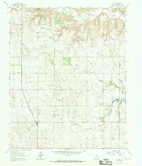
1964 Map of Lutie
USGS Topo · Published 1967About this map
Lutie stands as a focal point in this 1960s survey of Collingsworth County, situated along the path of Highway 83. The landscape is defined by the drainage basins of Elm Creek, Corral Creek, and Wolf Creek, which carve through the Texas Panhandle terrain. This period shows a rural economy transitioning through natural resource extraction, evidenced by numerous Gas Well and Drill Hole sites scattered across the township. Further east, the settlement of Aberdeen remains a notable landmark for local historians. The map also records specific infrastructure of the time, such as the Water Tank near Lutie and an extensive network of fence lines, providing a detailed look at land division and ranching boundaries during the mid-20th century.
Find a feature on this map
9 named features on this map. Tap any name to fly to it.
Don’t see what you’re looking for? This feature index may not catch every label — zoom into the map to look around manually.
Map Details
Editions of this 1964 Lutie Map
This is the sole edition of this map. No revisions or reprints were ever made.
Other maps of this area

1954 · Amarillo
USGS Topo · 1:250,000

1954 · Plainview
USGS Topo · 1:250,000

1958 · Amarillo
USGS Topo · 1:250,000

1958 · Plainview
USGS Topo · 1:250,000

1959 · Wellington NW
USGS Topo · 1:24,000

1959 · Shinnery Creek
USGS Topo · 1:24,000

1963 · Fulller
USGS Topo · 1:24,000

1963 · Shamrock East
USGS Topo · 1:24,000

1963 · Shamrock West
USGS Topo · 1:24,000

1963 · Little Wolf Creek
USGS Topo · 1:24,000