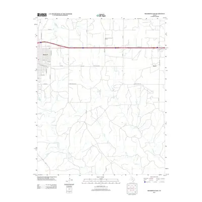
2012 Map of Shamrock East
USGS Topo · Published 2012About this map
Shamrock sits at a critical junction in Wheeler County, where the grid of city streets like N Tennessee St and E Commercial St transitions into the expansive ranching country of the Texas Panhandle. The landscape is defined by the winding paths of Hackberry Cr and Elm Cr, which cut through the terrain south of the town center. To the east, the settlement of Norrick is situated along Ranch Road 1802, serving as a smaller outlying hub connected by a network of county roads such as Co Rd 23. Aviation and commerce are central to the area's modern footprint, anchored by the Shamrock Municipal Airport and the Co Road Shopping Ctr. Water sources like Stagg Lake and Lehman Springs provide vital points of interest in a region primarily defined by its agricultural and transportation corridors.
Find a feature on this map
35 named features on this map. Tap any name to fly to it.
Don’t see what you’re looking for? This feature index may not catch every label — zoom into the map to look around manually.
Map Details
Editions of this 2012 Shamrock East Map
This is the sole edition of this map. No revisions or reprints were ever made.
Other maps of this area

1954 · Amarillo
USGS Topo · 1:250,000

1958 · Amarillo
USGS Topo · 1:250,000

1962 · Twitty
USGS Topo · 1:24,000

1962 · Kelton SE
USGS Topo · 1:24,000

1962 · Wheeler SE
USGS Topo · 1:24,000

1963 · Fulller
USGS Topo · 1:24,000

1963 · Shamrock East
USGS Topo · 1:24,000

1963 · Shamrock West
USGS Topo · 1:24,000

1963 · Little Wolf Creek
USGS Topo · 1:24,000
1964 · Dozier
USGS Topo · 1:24,000