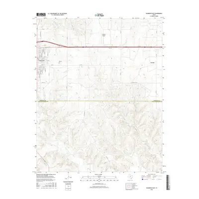
2016 Map of Shamrock East
USGS Topo · Published 2016About this map
The town of Shamrock anchors this Texas Panhandle landscape, where the grid of residential streets like N Texas St and E 12th St meets the open ranchland of Wheeler County. Just east of the main settlement lies the Shamrock Cem and the Shamrock Municipal Airport, serving as localized hubs for the community's infrastructure. To the east, the small rail-aligned settlement of Norrick marks a distinct point of interest for researchers of local transport and commerce.
Find a feature on this map
58 named features on this map. Tap any name to fly to it.
Don’t see what you’re looking for? This feature index may not catch every label — zoom into the map to look around manually.
Map Details
Editions of this 2016 Shamrock East Map
This is the sole edition of this map. No revisions or reprints were ever made.
Other maps of this area

1954 · Amarillo
USGS Topo · 1:250,000

1958 · Amarillo
USGS Topo · 1:250,000

1962 · Twitty
USGS Topo · 1:24,000

1962 · Kelton SE
USGS Topo · 1:24,000

1962 · Wheeler SE
USGS Topo · 1:24,000

1963 · Fulller
USGS Topo · 1:24,000

1963 · Shamrock East
USGS Topo · 1:24,000

1963 · Shamrock West
USGS Topo · 1:24,000

1963 · Little Wolf Creek
USGS Topo · 1:24,000
1964 · Dozier
USGS Topo · 1:24,000