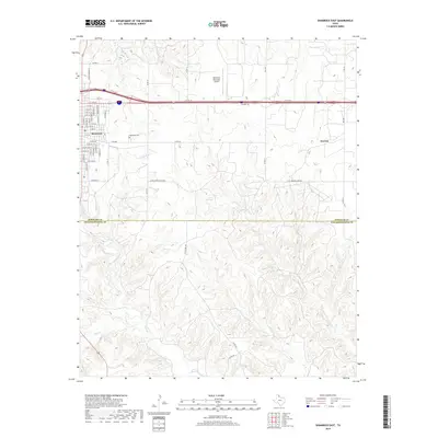
2019 Map of Shamrock East
USGS Topo · Published 2019About this map
Shamrock anchors the northwestern corner of this Texas Panhandle landscape, where the flat upland plains begin to break into the eroded drainage basins of the eastern Rolling Plains. The grid of the town is well-defined, transitioning from residential streets like N Madden St and E 12th St toward the Shamrock Municipal Airport and the Shamrock Cem to the east. South of town, the terrain transforms as it crosses the Wheeler Co Collingsworth Co line. The northern portion is dominated by agricultural allotments and the infrastructure of the I-40 Svc Rd, while the southern half reveals a dense network of seasonal watercourses. Steeply incised valleys formed by Hackberry Cr, Raven Cr, and Crow Cr create a complex topographical pattern, leading toward the isolated settlement of Norrick and the landmark Lehman Springs.
Find a feature on this map
56 named features on this map. Tap any name to fly to it.
Don’t see what you’re looking for? This feature index may not catch every label — zoom into the map to look around manually.
Map Details
Editions of this 2019 Shamrock East Map
This is the sole edition of this map. No revisions or reprints were ever made.
Other maps of this area

1954 · Amarillo
USGS Topo · 1:250,000

1958 · Amarillo
USGS Topo · 1:250,000

1962 · Twitty
USGS Topo · 1:24,000

1962 · Kelton SE
USGS Topo · 1:24,000

1962 · Wheeler SE
USGS Topo · 1:24,000

1963 · Fulller
USGS Topo · 1:24,000

1963 · Shamrock East
USGS Topo · 1:24,000

1963 · Shamrock West
USGS Topo · 1:24,000

1963 · Little Wolf Creek
USGS Topo · 1:24,000
1964 · Dozier
USGS Topo · 1:24,000