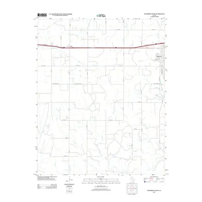
2012 Map of Shamrock West
USGS Topo · Published 2012About this map
Shamrock anchors the eastern edge of this Texas Panhandle landscape, where the town grid meets the drainage systems of the rolling plains. The western outskirts of the city are defined by a network of streets including S Arkansas St and W 8th St, transitioning quickly into the open ranching and agricultural lands of Wheeler County. Further west, the small settlement of Lela sits along the primary east-west transport corridor, surrounded by a expansive grid of county roads such as CO Road A and CO Road B.
Find a feature on this map
36 named features on this map. Tap any name to fly to it.
Don’t see what you’re looking for? This feature index may not catch every label — zoom into the map to look around manually.
Map Details
Editions of this 2012 Shamrock West Map
This is the sole edition of this map. No revisions or reprints were ever made.
Other maps of this area

1954 · Amarillo
USGS Topo · 1:250,000

1958 · Amarillo
USGS Topo · 1:250,000

1962 · Twitty
USGS Topo · 1:24,000

1962 · Wheeler SE
USGS Topo · 1:24,000

1962 · Pakan
USGS Topo · 1:24,000

1963 · Ramsdell
USGS Topo · 1:24,000

1963 · Shamrock East
USGS Topo · 1:24,000

1963 · Shamrock West
USGS Topo · 1:24,000
1964 · Abra
USGS Topo · 1:24,000
1964 · Dozier
USGS Topo · 1:24,000