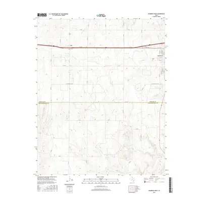
2016 Map of Shamrock West
USGS Topo · Published 2016About this map
Lela and the western edge of Shamrock sit along the Interstate 40 corridor, reflecting the modern commercial and residential development of this Texas Panhandle landscape. While the northern portion is defined by the street grid of Shamrock and the smaller community of Lela, the southern expanse transitions into an open, drainage-rich territory divided by the Wheeler Co Collingsworth Co line. Numerous intermittent waterways including Long Dry Cr, Roundup Cr, and Dozier Cr carve through the terrain, illustrating the complex natural irrigation patterns of the region.
Find a feature on this map
41 named features on this map. Tap any name to fly to it.
Don’t see what you’re looking for? This feature index may not catch every label — zoom into the map to look around manually.
Map Details
Editions of this 2016 Shamrock West Map
This is the sole edition of this map. No revisions or reprints were ever made.
Other maps of this area

1954 · Amarillo
USGS Topo · 1:250,000

1958 · Amarillo
USGS Topo · 1:250,000

1962 · Twitty
USGS Topo · 1:24,000

1962 · Wheeler SE
USGS Topo · 1:24,000

1962 · Pakan
USGS Topo · 1:24,000

1963 · Ramsdell
USGS Topo · 1:24,000

1963 · Shamrock East
USGS Topo · 1:24,000

1963 · Shamrock West
USGS Topo · 1:24,000
1964 · Abra
USGS Topo · 1:24,000
1964 · Dozier
USGS Topo · 1:24,000