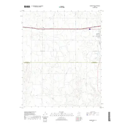
2019 Map of Shamrock West
USGS Topo · Published 2019About this map
Shamrock sits at the eastern edge of this Panhandle landscape, where the town grid transitions into the expansive ranch and farm lands of Wheeler County. The Interstate 40 corridor serves as the primary modern artery, passing through the small community of Lela and providing access to historical local markers like Lela Cem. This 2019 survey documents a terrain defined by intermittent drainage systems, including Roundup Cr, Long Dry Cr, and Elm Cr, which carve shallow paths across the high plains. The boundary with Collingsworth County to the south marks a shift toward more broken country near Dozier Cr. Local roads and rural routes like FM 1547 and FM 3075 connect the scattered homesteads and family sites, including Bowers Cem, reflecting the enduring settlement patterns of this cattle-country region.
Find a feature on this map
43 named features on this map. Tap any name to fly to it.
Don’t see what you’re looking for? This feature index may not catch every label — zoom into the map to look around manually.
Map Details
Editions of this 2019 Shamrock West Map
This is the sole edition of this map. No revisions or reprints were ever made.
Other maps of this area

1954 · Amarillo
USGS Topo · 1:250,000

1958 · Amarillo
USGS Topo · 1:250,000

1962 · Twitty
USGS Topo · 1:24,000

1962 · Wheeler SE
USGS Topo · 1:24,000

1962 · Pakan
USGS Topo · 1:24,000

1963 · Ramsdell
USGS Topo · 1:24,000

1963 · Shamrock East
USGS Topo · 1:24,000

1963 · Shamrock West
USGS Topo · 1:24,000
1964 · Abra
USGS Topo · 1:24,000
1964 · Dozier
USGS Topo · 1:24,000