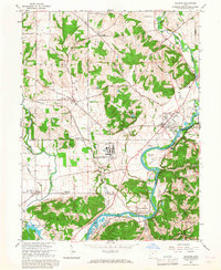
1965 Map of Shandon
USGS Topo · Published 1968About this map
The U S Reservation (Atomic Energy Commission) occupies a significant central portion of this landscape, marking the era of mid-century industrial and military expansion along the Great Miami River. This facility near Fernald stands in contrast to the surrounding agricultural terrain, which is dotted with numerous ancestral burial grounds like Shaker Cem and Sater Cem. The river's meandering course dictates the settlement patterns, with New Baltimore and Ross situated near its banks, while the Chesapeake and Ohio railroad corridor links smaller hamlets like Shandon and Shandon Sta. To the southwest, the Miami Whitewater Forest preserves a large tract of woodland, providing a natural buffer in a region increasingly defined by the transit of pipelines and regional road networks such as the New London Road.
Find a feature on this map
56 named features on this map. Tap any name to fly to it.
Don’t see what you’re looking for? This feature index may not catch every label — zoom into the map to look around manually.
Map Details
Editions of this 1965 Shandon Map
3 editions found
Other maps of this area

1914 · West Cincinnati
USGS Topo · 1:62,500

1915 · Lawrenceburg
USGS Topo · 1:48,000

1915 · Harrison
USGS Topo · 1:48,000

1915 · Hamilton
USGS Topo · 1:62,500

1917 · Hamilton
USGS Topo · 1:62,500

1928 · Lawrenceburg
USGS Topo · 1:62,500

1932 · Lawrenceburg
USGS Topo · 1:62,500

1943 · Hooven
USGS Topo · 1:24,000

1953 · Cincinnati West
USGS Topo · 1:24,000

1953 · Cincinnati
USGS Topo · 1:250,000