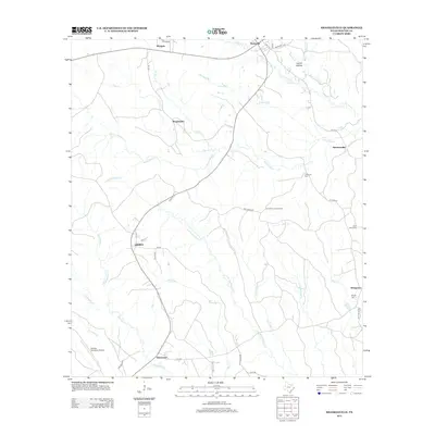
2012 Map of Shankleville
USGS Topo · Published 2012About this map
Shankleville stands at the center of this East Texas survey, surrounded by a complex network of bayous and creeks that define the local geography. The landscape is marked by several small communities connected by rural roads, including Wiergate to the north and Simmonsville to the east. Water features such as Yellow Bayou, Little Quicksand Cr, and Richland Br drain the territory, while the Burkeville Lookout Tower provides a notable landmark in the eastern hills. For those researching local family history, the map identifies several burial sites, including Simmons Cem, Saint Johns Cem, and Griggs Cem near Stringtown. The southern edge of the quadrangle reaches the Newton Municipal Airport and the settlement of Quicksand, illustrating the transition from traditional rural settlements to modern regional infrastructure.
Find a feature on this map
44 named features on this map. Tap any name to fly to it.
Don’t see what you’re looking for? This feature index may not catch every label — zoom into the map to look around manually.
Map Details
Editions of this 2012 Shankleville Map
This is the sole edition of this map. No revisions or reprints were ever made.
Other maps of this area

1944 · Wiergate
USGS Topo · 1:62,500

1946 · Merryville
USGS Topo · 1:31,680

1948 · Wiergate
USGS Topo · 1:62,500

1949 · Evans
USGS Topo · 1:31,680

1952 · Lake Charles
USGS Topo · 1:250,000

1953 · Alexandria
USGS Topo · 1:250,000
1954 · Merryville
USGS Topo · 1:31,680

1954 · Wiergate
USGS Topo · 1:24,000

1954 · Wiergate SE
USGS Topo · 1:24,000

1954 · Wiergate
USGS Topo · 1:62,500