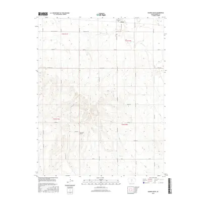
2015 Map of Sharon South
USGS Topo · Published 2015About this map
Sharon anchors the northern edge of this Barber County landscape, where the town's grid meets the expansive agricultural section lines of southern Kansas. The terrain is defined by the drainage systems of Little Sandy Cr and Salty Cr, which carve subtle variations into the prairie. Local history is grounded at the Sharon Cem and the distinctive geographical landmark of Lone Tree Canyon. The map reveals a highly structured rural network of named roads such as Crooked Post, College Hill Rd, and Grama Rd, reflecting the enduring township and range system. This 2015 data provides a clear look at the modern rural layout, from the higher elevations of College Hill to the seasonal watercourses that shape the local ranching and farming economy.
Find a feature on this map
29 named features on this map. Tap any name to fly to it.
Don’t see what you’re looking for? This feature index may not catch every label — zoom into the map to look around manually.
Map Details
Editions of this 2015 Sharon South Map
This is the sole edition of this map. No revisions or reprints were ever made.
Other maps of this area

1889 · Anthony
USGS Topo · 1:125,000

1891 · Medicine Lodge
USGS Topo · 1:125,000

1891 · Anthony
USGS Topo · 1:125,000

1893 · Medicine Lodge
USGS Topo · 1:125,000

1955 · Pratt
USGS Topo · 1:250,000

1959 · Pratt
USGS Topo · 1:250,000

1972 · Sharon South
USGS Topo · 1:24,000
1972 · Kiowa
USGS Topo · 1:24,000
1972 · Corwin
USGS Topo · 1:24,000

1972 · Crisfield
USGS Topo · 1:24,000