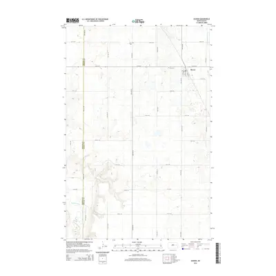
2014 Map of Sharon
USGS Topo · Published 2014About this map
Sharon serves as the primary hub of this eastern North Dakota agricultural landscape, where the grid of rural roads meets the headwaters of the Middle Br Goose River. The town's layout is centered on Main St and the local Po, providing a focal point for the surrounding farmstead network. To the south and west, the terrain transitions toward the valley of the Sheyenne River, which cuts across the southwestern corner of the quadrangle. For those researching local families, the map clearly identifies two significant burial sites: the Sharon Cem just west of the town center and the Trinity Cem located further north along the Griggs Co and Steele Co boundary line. This 2014 survey documents a region defined by its rigid section lines and persistent reliance on the river branches that drain the high plains.
Find a feature on this map
27 named features on this map. Tap any name to fly to it.
Don’t see what you’re looking for? This feature index may not catch every label — zoom into the map to look around manually.
Map Details
Editions of this 2014 Sharon Map
This is the sole edition of this map. No revisions or reprints were ever made.
Other maps of this area

1952 · Grand Forks
USGS Topo · 1:250,000

1952 · New Rockford
USGS Topo · 1:250,000

1956 · New Rockford
USGS Topo · 1:250,000

1956 · Grand Forks
USGS Topo · 1:250,000

1961 · Cooperstown East
USGS Topo · 1:24,000

1966 · Grand Forks
USGS Topo · 1:250,000

1967 · Finley NE
USGS Topo · 1:24,000

1967 · Blabon
USGS Topo · 1:24,000
1967 · Kloten SE
USGS Topo · 1:24,000

1967 · Finley
USGS Topo · 1:24,000