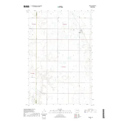
2017 Map of Sharon
USGS Topo · Published 2017About this map
Sharon serves as the primary hub for this portion of eastern North Dakota, situated where Co Hwy 7 meets several section-line roads. The landscape is defined by the headwaters and drainage patterns of two distinct river systems: the Middle Br Goose River in the northeast and the winding course of the Sheyenne River in the southwest corner. These watercourses cut through a landscape otherwise marked by a high density of small wetlands and potholes typical of the glaciated plains. For researchers, the map identifies local landmarks such as the Po in town and two burial grounds, Trinity Cem and Sharon Cem, which sit north of the main settlement. The boundary between Griggs and Steele Counties runs vertically through the western half of the sheet, dividing the township grids of T148N and T147N.
Find a feature on this map
19 named features on this map. Tap any name to fly to it.
Don’t see what you’re looking for? This feature index may not catch every label — zoom into the map to look around manually.
Map Details
Editions of this 2017 Sharon Map
This is the sole edition of this map. No revisions or reprints were ever made.
Other maps of this area

1952 · Grand Forks
USGS Topo · 1:250,000

1952 · New Rockford
USGS Topo · 1:250,000

1956 · New Rockford
USGS Topo · 1:250,000

1956 · Grand Forks
USGS Topo · 1:250,000

1961 · Cooperstown East
USGS Topo · 1:24,000

1966 · Grand Forks
USGS Topo · 1:250,000

1967 · Finley NE
USGS Topo · 1:24,000

1967 · Blabon
USGS Topo · 1:24,000
1967 · Kloten SE
USGS Topo · 1:24,000

1967 · Finley
USGS Topo · 1:24,000