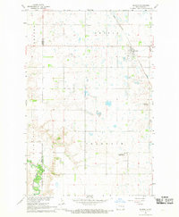
1967 Map of Sharon
USGS Topo · Published 1969About this map
Sharon serves as the central hub for this portion of eastern North Dakota, situated along the Great Northern railroad line during the late 1960s. The landscape is defined by the prairie potholes and meandering water systems characteristic of the region, including the Middle Fork Goose River in the northeast and the Sheyenne River winding through the southwest corner. The transition between the townships of Sharon, Franklin, Lenora, and Romness is marked by a survey grid that accommodates significant local landmarks like the Trinity Cem and Sharon Cem. Of particular interest to local researchers is the presence of the US Military Reservation in the southern portion of the quadrangle and the Hill and Dale Golf Club to the east. The map captures the interface between Griggs and Steele Counties, documenting the rural infrastructure and scattered Gravel Pits that supported the agricultural economy of the era.
Find a feature on this map
14 named features on this map. Tap any name to fly to it.
Don’t see what you’re looking for? This feature index may not catch every label — zoom into the map to look around manually.
Map Details
Editions of this 1967 Sharon Map
This is the sole edition of this map. No revisions or reprints were ever made.
Other maps of this area

1952 · Grand Forks
USGS Topo · 1:250,000

1952 · New Rockford
USGS Topo · 1:250,000

1956 · New Rockford
USGS Topo · 1:250,000

1956 · Grand Forks
USGS Topo · 1:250,000

1961 · Cooperstown East
USGS Topo · 1:24,000

1966 · Grand Forks
USGS Topo · 1:250,000

1967 · Finley NE
USGS Topo · 1:24,000

1967 · Blabon
USGS Topo · 1:24,000
1967 · Kloten SE
USGS Topo · 1:24,000

1967 · Finley
USGS Topo · 1:24,000