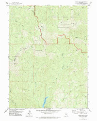
1978 Map of Shasta Bally
USGS Topo · Published 1978About this map
Whiskeytown Shasta Trinity National Recreation Area dominates the northern reaches of this topographic study, where high peaks and deep gulches define the wilderness boundary between Trinity and Shasta Counties. The landscape is anchored by massive local summits including Shasta Bally, Buckhorn Bally, and Shoemaker Bally, providing a clear view of the high-elevation terrain before modern development. In the southern half, the hydrological network of Cottonwood Creek and its tributaries, such as Moon Fork and North Fork, converge toward Rainbow Lake. This reservoir is contained by the Musselbeck Dam, reflecting the mid-century water management infrastructure of the region. Remote access points like the Jerusalem Trail and various pack trails illustrate how this backcountry was traversed during the late 1970s.
Find a feature on this map
37 named features on this map. Tap any name to fly to it.
Don’t see what you’re looking for? This feature index may not catch every label — zoom into the map to look around manually.
Map Details
Editions of this 1978 Shasta Bally Map
This is the sole edition of this map. No revisions or reprints were ever made.
Other maps of this area

1890 · Red Bluff
USGS Topo · 1:250,000

1894 · Red Bluff
USGS Topo · 1:250,000

1913 · Weaverville
USGS Topo · 1:125,000

1944 · French Gulch
USGS Topo · 1:62,500

1948 · French Gulch
USGS Topo · 1:62,500

1950 · Weaverville
USGS Topo · 1:62,500

1951 · Chanchelulla Peak
USGS Topo · 1:62,500

1952 · Weaverville
USGS Topo · 1:62,500

1952 · Ono
USGS Topo · 1:62,500

1958 · Redding
USGS Topo · 1:250,000