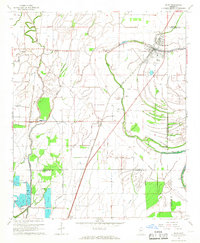
1967 Map of Shaw
USGS Topo · Published 1968About this map
The town of Shaw serves as the central hub of this Delta landscape during the late 1960s, situated at the junction of the Illinois Central railroad and Porter Bayou. The terrain is defined by its intricate hydrological network, featuring the winding Bogue Phalia and the Pecan Bayou Cutoff, alongside modern agricultural developments like the Fish Farm near Napanee. Local heritage is deeply etched into the land, from the Old Indian Treaty Boundary cutting across the survey to the multiple Indian Mound sites preserved near the bayou bends.
Find a feature on this map
32 named features on this map. Tap any name to fly to it.
Don’t see what you’re looking for? This feature index may not catch every label — zoom into the map to look around manually.
Map Details
Editions of this 1967 Shaw Map
2 editions found
Other maps of this area

1934 · Cleveland
USGS Topo · 1:62,500

1939 · Tralake
USGS Topo · 1:62,500

1939 · Choctaw
USGS Topo · 1:62,500

1940 · Baird
USGS Topo · 1:62,500

1940 · Cleveland
USGS Topo · 1:62,500

1953 · Greenwood
USGS Topo · 1:250,000

1956 · Greenwood
USGS Topo · 1:250,000

1965 · Indianola
USGS Topo · 1:24,000

1966 · Cleveland
USGS Topo · 1:24,000

1967 · Baird
USGS Topo · 1:62,500