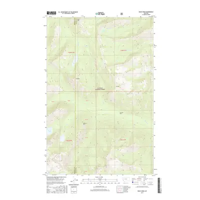
2017 Map of Shaw Creek
USGS Topo · Published 2017About this map
Flathead National Forest encompasses this wilderness area where high-elevation landmarks define the boundary between Missoula and Powell counties. The landscape is dominated by significant peaks and ridges, including Lena Peak, Shaw Mtn, and Trio Mtn, which overlook a network of alpine basins and creek drainages. This high-country geography forms the headwaters for several important waterways, notably Big Salmon Cr and Shaw Cr. Deep within these mountain folds, distinct bodies of water like Lena Lake and the Big Knife Lakes are tucked into glacial cirques, while lower areas like Shirttail Park provide rare level ground amidst the steep terrain. The mapping reveals a preserved environment of drainage systems like Gordon Cr and Doctor Cr, showing how the land was surveyed for the national forest system before modern development.
Find a feature on this map
25 named features on this map. Tap any name to fly to it.
Don’t see what you’re looking for? This feature index may not catch every label — zoom into the map to look around manually.
Map Details
Editions of this 2017 Shaw Creek Map
This is the sole edition of this map. No revisions or reprints were ever made.
Other maps of this area

1902 · Ovando
USGS Topo · 1:125,000

1905 · Ovando
USGS Topo · 1:125,000

1921 · Elbow Lake
USGS Topo · 1:125,000

1936 · Silvertip
USGS Topo · 1:96,000

1942 · Silvertip
USGS Topo · 1:125,000

1955 · Choteau
USGS Topo · 1:250,000

1957 · Choteau
USGS Topo · 1:250,000

1958 · Choteau
USGS Topo · 1:250,000

1962 · Choteau
USGS Topo · 1:250,000

1965 · Holland Lake
USGS Topo · 1:24,000