
2011 Map of Shaw Island
USGS Topo · Published 2011About this map
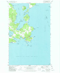
The San Juan Channel and Upright Channel define the nautical landscape of this 2011 survey, centered on the ferry-dependent life of Shaw Island. At the heart of the region, the Shaw Island Post Office and nearby Shaw Island County Park Campground serve as central community hubs. To the north, the steep terrain of Orcas Island rises toward Diamond Hill, while the settlement at Orcas maintains essential transit links via the Orcas Ferry Landing.
Find a feature on this map
151 named features on this map. Tap any name to fly to it.
Don’t see what you’re looking for? This feature index may not catch every label — zoom into the map to look around manually.
Map Details
Editions of this 2011 Shaw Island Map
This is the sole edition of this map. No revisions or reprints were ever made.
Other maps of this area

1943 · Richardson
USGS Topo · 1:62,500

1943 · Orcas Island
USGS Topo · 1:62,500

1954 · Waldron Island
USGS Topo · 1:24,000

1954 · Friday Harbor
USGS Topo · 1:24,000

1954 · False Bay
USGS Topo · 1:24,000

1957 · Richardson
USGS Topo · 1:62,500

1957 · Orcas Island
USGS Topo · 1:62,500

1957 · Victoria
USGS Topo · 1:250,000
1973 · Lopez Pass
USGS Topo · 1:24,000

1973 · Shaw Island
USGS Topo · 1:24,000