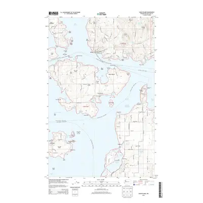
2014 Map of Shaw Island
USGS Topo · Published 2014About this map
Shaw Island and the surrounding reaches of the San Juan Islands are defined by a complex maritime geography of ferry landings, secluded coves, and rugged island interiors. This 2014 survey details the vital transportation links that sustain these communities, including the Shaw Ferry Landing and the Lopez Ferry Landing, which facilitate travel across the Harney Channel and Upright Channel. The map documents a landscape where traditional coastal settlements like Lopez Village and Orcas coexist with specialized infrastructure such as Wilding Farm Airport and Windsock Airport.
Find a feature on this map
161 named features on this map. Tap any name to fly to it.
Don’t see what you’re looking for? This feature index may not catch every label — zoom into the map to look around manually.
Map Details
Editions of this 2014 Shaw Island Map
This is the sole edition of this map. No revisions or reprints were ever made.
Other maps of this area

1943 · Richardson
USGS Topo · 1:62,500

1943 · Orcas Island
USGS Topo · 1:62,500

1954 · Waldron Island
USGS Topo · 1:24,000

1954 · Friday Harbor
USGS Topo · 1:24,000

1954 · False Bay
USGS Topo · 1:24,000

1957 · Richardson
USGS Topo · 1:62,500

1957 · Orcas Island
USGS Topo · 1:62,500

1957 · Victoria
USGS Topo · 1:250,000
1973 · Lopez Pass
USGS Topo · 1:24,000

1973 · Shaw Island
USGS Topo · 1:24,000